Cast – Cable Analysis Software Tool
Challenges revolving around subsea cable fatigue and cable stability have been identified as main areas of concern for marine renewable energy projects; for subsea cables to meet their design life and remain cost-effective, movement and vibration should be minimised. Although this can be achieved by external cable protection measures, the need for these systems can be partly mitigated by optimising cable routes.
CAST is a unique software tool developed to optimise subsea power cable routes. Designed around a revolutionary cable analysis methodology the tool combines a cable’s hydrodynamic properties with the seabed geometry to assess its stability. Using multiple iterations, it provides the optimal route within the pre-set requirements. Using user centric 2D and 3D visualisation techniques with intuitive routing controls, the tool provides appealing, useful insights in different routing options and their advantages and disadvantages.
Cable Route Analysis
Cable Route Optimisation
CFD Integration
RPL Reporting
Factor of Safety Analysis
GIS Integration
A Geographic Information System (GIS)
CAST works with a Geographic Information System (GIS) and offers integration with external databases for bathymetry, flow velocities, shorelines, existing cables, survey data, navigational charts, and installed project assets such as wind/wave/tidal turbines. CAST can also import and intuitively translate data from other GIS databases in a variety of formats, projections and datums.
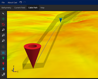
Cable Path Definition
By generating geo-referenced colour-coded ‘heat’ maps based on velocity flows over bathymetric surfaces users are provided with an unrivalled perspective of the optimum cable route. Intelligent zooming and navigating along the route in the plan, profile and 3D views provide additional details along the route.
Cable Parameters
CAST allows a range of cable parameters including minimum bend radius (MBR), cable diameter, mass per unit length, bending and axial stiffness which is used to calculate both the lift and drag coefficients. From this information, the critically important transverse flows required to displace the cable is generated. Lay corridors are generated around the cable path, providing initial boundaries of the optimal route.
Line Statics Calculation for Spanning
Every time a new cable route (Start, End and Waypoints) is generated by the user, CAST instantly calculates the plan route, taking into account the minimum bending radius of the cable. Once this plan route is calculated, it determines the lay of the cable on the bathymetry using an internal Finite-Element model considering all supplied cable parameters. This allows for easy identification and inspection of spans along the cable length and their possible impact on the cable.
Instant Profiles
CAST computes the bottom profile along the seabed and is capable of visualising high resolution point cloud data. Cross sectional depth profiles are displayed along with Factor of Safety (FoS) and current velocity at each point. All calculations and Kilometre Pole (KP) route distances are accurately computed and displayed. Reports can be generated in an efficient and concise manner.
Standardized RPL generation
The user can instantly complete a detailed and accurate Route Position List (RPL) report which can be edited and exported for any target cable. Users can show X,Y,Z positions in addition to the geographic/WGS84 positions. The report uses standardized electronic formatting defined by the International Cable Protection Committee (ICPC).
Bathymetry Fields
CAST allows the user to accurately interpret and visualize high resolution point data collected within the entire area of interest. This allows the indication of any potential natural or man-made obstructions surrounding the cable route. All the surfaces created can be automatically geo-referenced as GeoTIFFs and viewable as layers on the main CAST Map window.
Current Fields
CAST allows importing of advanced Computational Fluid Dynamic (CFD) surfaces generated to show velocity current at or offset from the seabed. Combined with these advanced models, the bathymetric field provides an optimised perspective of the cable route.
Wave and Tidal Regime
CAST uses linear wave theory to model the effect of wave-induced flows on the cable. By specifying the design wave height, direction and period, cable engineers can immediately view the impact of waves on the stability of the cable.
Map Window
The map window allows all project data to be viewed and charted, allowing for easy presentation to project stakeholders.